Modern consumer and professional drones are equipped with powerful hardware, but the true leap in capability often comes from software. Advanced drone control applications such as Litchi have transformed what pilots can achieve, enabling complex autonomous flights, cinematic camera movements, and precision mission planning that would be difficult or impossible using standard manufacturer apps alone. For commercial operators, filmmakers, surveyors, and serious hobbyists, these tools represent a significant step toward safer, more efficient, and more creative drone operations.
TLDR: Advanced drone control tools like Litchi unlock powerful mission planning, waypoint automation, and camera control features that surpass basic flight apps. They enable precise, repeatable, and autonomous operations suitable for professional and complex projects. With proper setup and responsible use, these tools greatly enhance both creative and commercial drone work. However, pilots must understand airspace, safety, and firmware compatibility to fully benefit from their capabilities.
Understanding Advanced Drone Control Software
Most consumer drones ship with native applications that allow manual flight, basic automated modes, and firmware management. While these apps are sufficient for casual use, they often limit mission complexity and customization. Tools like Litchi act as advanced overlays, giving operators deeper access to flight path logic and camera behavior.
At their core, these applications provide:
- Waypoint mission planning with detailed altitude, speed, and heading control
- Automated camera triggers for consistent imagery
- Orbit and focus modes for cinematic shots
- Virtual reality or FPV enhancements for immersive control
- Pre-mission simulation and preview tools
This added layer of functionality turns a drone from a remotely piloted camera platform into a programmable aerial system.
Waypoint Missions: The Core of Automation
The most powerful feature in tools like Litchi is waypoint-based mission planning. Instead of manually flying a route in real time, a pilot can define a sequence of precise GPS coordinates, assign altitude changes, set airspeed, and even specify exact gimbal angles at each point.
Image not found in postmetaEach waypoint can typically include:
- Altitude above takeoff or ground level
- Flight speed
- Heading direction
- Gimbal pitch
- Photo or video capture commands
- Hover duration
This level of granularity allows repeatable missions. For example, a construction company documenting project progress can run the exact same route weekly. This consistency improves visual comparison and reporting accuracy. Similarly, filmmakers can execute identical camera movements across multiple takes.
Cinematic Control for Filmmakers
Professional video production often requires smooth, predictable, and repeatable movement. Manual stick control, even by experienced pilots, can produce slight inconsistencies. Advanced drone tools minimize this problem by allowing pre-programmed curves and smooth transitions between waypoints.
Features such as point of interest tracking enable the drone to lock onto a subject while flying a circular or complex path. The pilot can define the radius, altitude, and rotation speed. The result is fluid, cinematic motion without abrupt inputs.
For content creators, this means:
- Reduced need for multiple retakes
- Enhanced precision in camera framing
- More ambitious creative shots
- Reduced pilot workload during complex sequences
By separating navigation planning from manual input, operators can focus more attention on safety, timing, and artistic intent.
Improved Efficiency for Commercial Applications
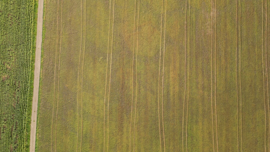
Commercial drone workflows demand both accuracy and efficiency. Real estate photographers, agricultural surveyors, and infrastructure inspectors benefit from automated grid patterns and structured flight routes.
For example, in mapping scenarios, grid missions ensure consistent overlap between images. Overlap is critical for photogrammetry processing software to stitch together accurate orthomosaics and 3D models. Automated triggers eliminate human error caused by delayed button presses.
In agriculture, consistent altitude and speed improve data quality for crop health analysis. In powerline inspections, predefined waypoint paths help maintain safe distances from infrastructure while capturing detailed imagery.
The bottom line is operational reliability. Automated missions reduce variability and enable professional-grade deliverables.
Safety Considerations and Responsibility
While advanced control tools provide greater capability, they also require greater responsibility. Automated missions do not remove regulatory or operational obligations. Pilots must understand:
- Local airspace classifications
- Visual line of sight requirements
- Maximum altitude limits
- Obstacle awareness
- Weather conditions
Waypoint-based missions can carry risks if obstacles, signal interference, or terrain changes are not accounted for. Detailed pre-flight planning, including reviewing satellite imagery and checking NOTAMs or flight authorization systems where required, is essential.
It is also critical to confirm firmware compatibility between the drone and third-party applications. Incompatible updates can affect feature availability or flight stability. Serious operators test new firmware in controlled environments before deploying it in active projects.
Mission Hub and Desktop Planning
One of the most practical aspects of tools like Litchi is web-based mission planning. Instead of designing routes on a small mobile device screen, pilots can plan missions on a larger desktop interface, using detailed satellite or hybrid map views.
This workflow typically includes:
- Mapping waypoints with precision using a mouse and keyboard.
- Assigning altitude and camera commands.
- Simulating the mission in 3D preview.
- Synchronizing the plan to a mobile device for execution in the field.
For complex commercial projects, this separation of planning and execution increases efficiency. Teams can collaborate on mission design before arriving on site, reducing field setup time and minimizing exposure to environmental risks.
Repeatability and Data Integrity
In industries like surveying and environmental monitoring, repeatability is more valuable than creative flexibility. Advanced drone control applications allow missions to be saved, duplicated, and adjusted incrementally.
Consider shoreline erosion monitoring. A drone may be flown quarterly over the same coastal stretch. Identical waypoints ensure that photographic comparisons are scientifically valid. Even small variations in path or altitude could introduce interpretive inconsistencies.
By preserving mission data, advanced tools contribute directly to higher data integrity and defensible reporting.
Immersive and Specialized Modes
Many advanced platforms also include specialty modes such as:
- VR mode for immersive head-tracking flight
- Follow modes using GPS tracking
- Panorama automation for seamless 360-degree imagery
- Focus mode for independent yaw and movement control
While these features may appeal to enthusiasts, they also offer practical scenarios. For example, automated panorama capture ensures evenly spaced images for professional virtual tours. Focus mode gives dual-operator-style control, even when flying solo.
Limitations and Practical Constraints
No advanced control software eliminates physical and regulatory limits. Battery life remains finite. Signal range is dictated by transmission systems and local regulations. Environmental factors such as wind and electromagnetic interference can impact autonomous flights.
Additionally, GPS accuracy varies depending on satellite visibility and surrounding obstructions. Urban environments with tall buildings may introduce signal reflection errors that affect waypoint precision. Operators should use caution and maintain situational awareness even during automated missions.
Moreover, not all drone models support every advanced feature. Some manufacturers restrict third-party app integration on newer aircraft. Professionals should assess compatibility before making operational commitments.
Cost-Benefit Analysis for Professionals
Compared to the overall investment in drone hardware, licensing, insurance, and training, advanced control applications are typically a modest expense. Yet their impact on workflow efficiency and output quality can be substantial.
Benefits often include:
- Reduced on-site flight time
- Fewer retakes and corrections
- Improved deliverable consistency
- Enhanced creative flexibility
- Better data reliability
For commercial operators billing by project rather than by flight hour, the time savings alone can justify adoption.
Best Practices for Implementation
To use tools like Litchi effectively and responsibly, pilots should follow structured practices:
- Conduct thorough simulator tests before live missions.
- Start with simple waypoint routes and gradually increase complexity.
- Visually inspect the entire planned flight path for obstacles.
- Maintain manual override readiness at all times.
- Keep firmware, maps, and regulatory knowledge up to date.
Training and documentation are also advisable for teams managing multiple pilots. Standardized mission naming conventions and version controls prevent confusion and errors.
The Broader Impact on the Drone Industry
Advanced drone control software represents a maturation of the industry. As hardware becomes increasingly stable and intelligent, the value proposition shifts toward software-driven precision, automation, and repeatability.
For enterprise users, this evolution bridges the gap between hobbyist drones and industrial-grade unmanned aerial systems. For creative professionals, it opens new dimensions in aerial cinematography and storytelling. For technical operators, it enables structured aerial data acquisition.
Ultimately, tools like Litchi are not simply convenience apps. They are operational multipliers. When used responsibly and with proper technical understanding, they expand what is possible with existing drone platforms while reinforcing reliability and professionalism.
As regulatory frameworks evolve and hardware capability continues to improve, advanced control tools will likely become standard components of serious drone operations. Those who understand and master them today position themselves at the forefront of precision aerial work.